
2021-03-09
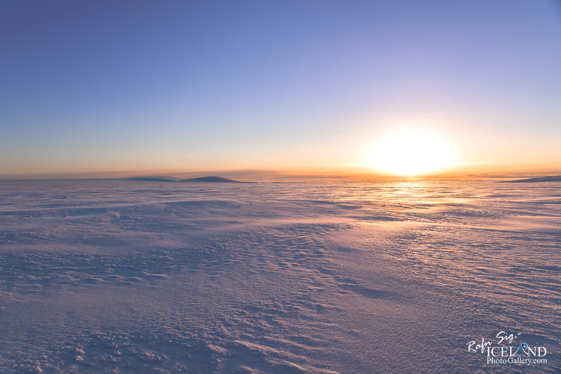
Mýrdalsjökull Glacier in the morning twilight │ Iceland Photo Gallery
Documenting Iceland
by: Rafn Sig,-
English below:
Að aka upp á Mýrdalsjökli við sólarupprás er eitthvað sem orð fá ekki lýst. Fegurðin er svo yfirgnæfandi að “núið” er það eina sem þú upplifir. Það er svo mikið af engu að hugurinn fyllist af hamingju.
Driving on top of Mýrdalsjökull Glacier in the morning twilight is something words can’t describe. The beauty is so overwhelming that “now” is the only thing you experience. There is so much of nothing that the mind is filled with happiness.
– – – –
Mýrdalsjökull er syðsti jökull á Íslandi og sá fjórði stæðsti að flatarmáli, hann þekur um það bil 600 km2 eða um 130 km3 af ís. Undir jöklinum er síðan eitt öflugasta eldfjall landsins, eldfjallið Katla. Kalta er gríðarstór en askja eldfjallsins er um 110 km2. Meðalþykkt jökulsins er um 220 metrar en sumstaðar er þykktin allt að 750 metrar.
Goðabunga er hæsti tindur jökulsins og er hann um 1515 metrar á hæð, næst hæsti er Háabunga sunnan í Mýrdalsjökli um 1500 metrar. Báðir þessir tindar eru þaktir snjó og er hæð þeirra því eitthvað breytileg eftir árstíma. Mikil snjósöfnun er á Mýrdalsjökli og getur þykkt snjóalaga eftir veturinn verið allt að 20 metrar. Þessi mikla snjósöfnun er vegna mikillar úrkomu á svæðinu en ársúrkoma á jöklinum getur verið allt að 7000 mm. (algeng meðalúrkoma á láglendi um 1000 mm á ári).
Margir skriðjöklar ganga niður úr Mýrdalsjökli, stæstur þeirra eru Sléttujökull til norðurs og Kötlujökull til Suðausturs. Þessir skriðjöklar hafa mótað landið á þessu svæði, Sólheimajökull sem gengur suður úr Mýrdalsjökuli hefur grafið sig í gegnum landslagið og undir jöklinum er djúpur dalur sem nær allt að 150 niður fyrir yfirborðið fyrir framan jökulinn. Árið 2007 byrjaði að myndast þar jökullón sem hefur farið ört stækkandi síðan. Undan þessum skriðjöklum koma jökulhlaup þegar Kötlugos verða.
– 0 –
Mýrdalsjökull is the southernmost glacier in Iceland and the fourth largest in area, it covers approximately 600 km2 or about 130 km3 of ice. Under the glacier is one of the most powerful volcanoes in the country, the volcano Katla. Kalta is huge but the volcano’s caldera is about 110 km2. The average thickness of the glacier is about 220 meters, but in some places the thickness is up to 750 meters.
Goðabunga is the highest peak of the glacier and it is about 1515 meters high, the next highest is Háabunga south of Mýrdalsjökull about 1500 meters. Both of these peaks are covered with snow and their height therefore varies somewhat depending on the season. There is a lot of snow accumulation on Mýrdalsjökull and the thickness of the snow layer after the winter can be up to 20 meters. This heavy snow accumulation is due to heavy rainfall in the area, but the annual rainfall on the glacier can be up to 7000 mm. (common average precipitation in the lowlands about 1000 mm per year).
Many glaciers descend from Mýrdalsjökull, the largest of which are Sléttujökull to the north and Kötlujökull to the southeast. These glaciers have shaped the land in this area, Sólheimajökull which runs . . . All info at: https://www.patreon.com/RafnSig
Subscribe to my Youtube Channel
You can buy this and other photos at my Icelandic Stock Photo Web: IcelandStockPhotos.com
Liked it?
Take a second to support me on Patreon

As a native photographer I feel responsible to leave all I can behind to show how it looked like, with my photography, before it’s too late.


0 Comments