
2022-04-30
On top of Eyjafjallajökull Volcano Glacier │ Iceland Photo Gallery
Documenting Iceland
by: Rafn Sig,-
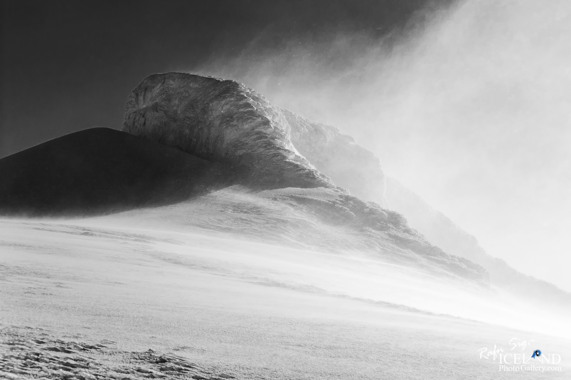
Eyjafjallajökull er sjötti stærsti jökull landsins, 1666 metra hár og þekur um 80 ferkílómetra.
Jökullinn telst til svonefndra hjarnjökla, sem eru einkennandi fyrir heimskautalönd og fjallendi þar sem veðrátta er köld. Ávallt eru þessir jöklar þykkir með flatt yfirborð sem hallar jafnt og þétt út til jaðranna, en til þessa flokks teljast stærstu jöklar jarðarinnar.
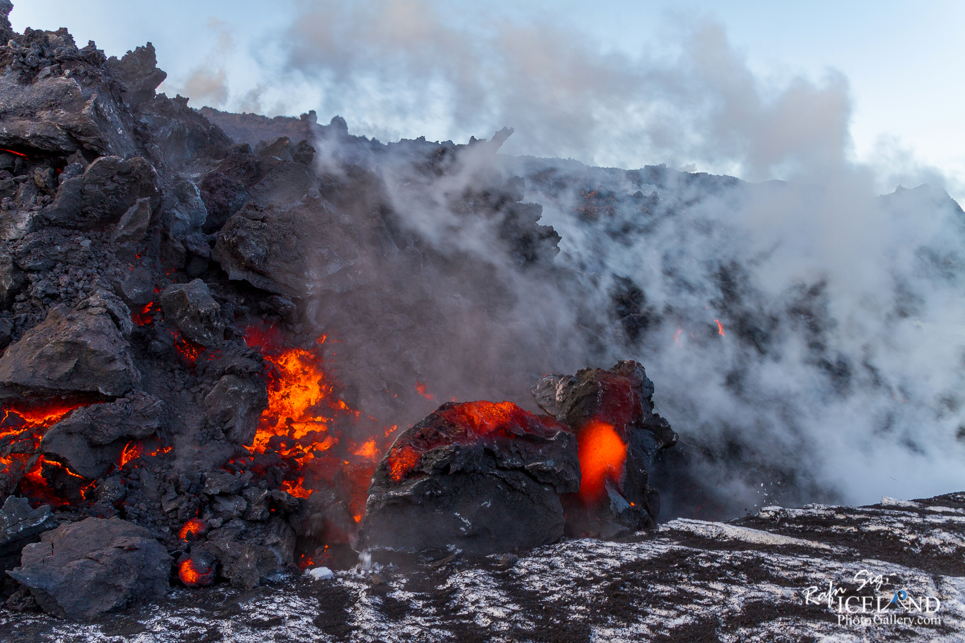
Undir jöklinum er eldkeila sem hefur gosið fjórum sinnum síðan land byggðist, fyrst árið 920, þá 1612, 1821 og 2010. Öll þessi gos hafa verið frekar lítil. Þegar gaus árið 1821 stóð gosið til ársins 1823. Gos hófst svo á Fimmvörðuhálsi þann 20. mars 2010 austan við Eyjafjallajökul. Þann 14. apríl 2010 hófst gos undir jökulhettunni.
Eyjafjallajökull hefur nokkra tinda í kringum hringlaga gíg sem er 3 – 4 km að þvermáli: Hámundur, Goðasteinn og Guðnasteinn, Hámundur er hæsti tindurinn eða ym 1640 metrar. Jökullinn sjálfur var mældur snemma á 20. öld af dönskum landmælingamönnum og var þá 1.666 m hár.
Úr jöklinum renna 2 skriðjöklar sem heita Steinsholtsjökull og Gígjökull en þeir skríða báðir til norðurs í átt að Þórsmörk. Hafa þeir á síðustu árum hörfað mikið og er Gígjökull nánast að hverfa.
Eyjafjallajökull og Mýrdalsjökull eru næst hvor öðrum á Fimmvörðuhálsi. Eyjafjallajökull er mjög varasamur til ferðalaga vegna jökulsprungna en jökullinn er mjög brattur og sprunginn.
Eyjafjallajökull is one of the smaller ice caps of Iceland, north of Skógar and west of Mýrdalsjökull. The ice cap covers the caldera of a volcano with a summit elevation of 1,651 metres (5,417 ft). The volcano has erupted relatively frequently since the last glacial period, most recently in 2010
Eyjafjallajökull consists of a volcano completely covered by an ice cap. The ice cap covers an area of about 100 square kilometres (39 sq mi), feeding many outlet glaciers. The main outlet glaciers are to the north: Gígjökull, flowing into Lónið, and Steinholtsjökull, flowing into Steinholtslón. In 1967, there was a massive landslide on the Steinholtsjökull glacial tongue. On 16 January 1967 at 13:47:55 there was an explosion on the glacier. It can be timed because the seismometers at Kirkjubæjarklaustur monitored the movement. When about 15,000,000 cubic metres (530,000,000 cubic feet) of material hit the glacier a massive amount of air, ice, and water began to move out from under the glacier into the lagoon at the foot of the glacier.
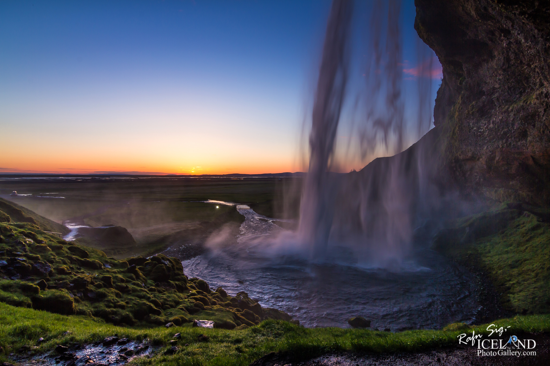
The mountain itself, a stratovolcano, stands 1,651 metres (5,417 ft) at its highest point, and has a crater 3–4 kilometres (1.9–2.5 mi) in diameter, open to the north. The crater rim has three main peaks (clockwise from the north-east): Guðnasteinn, 1,500 metres (4,900 ft); Hámundur, 1,651 metres (5,417 ft); and Goðasteinn, 1,497 metres (4,911 ft). The south face of the mountain was once part of Iceland’s coastline, from which, over thousands of years, the sea has retreated some 5 kilometres (3 mi). The former coastline now consists of sheer cliffs with many waterfalls, of which the best known is Skógafoss. In strong winds, the water of the smaller falls can even be blown up the mountain. The area between the mountain and the present coast is a relatively flat strand, 2 to 5 km (1 to 3 miles) wide, called Eyjafjöll.
. . . All info at: https://www.patreon.com/RafnSig
Subscribe to my Youtube Channel
You can buy this and other photos at my Icelandic Stock Photo Web: IcelandStockPhotos.com
Liked it?
Take a second to support me on Patreon

Viltu styrkja þessa síðu?
Vefsíðan Iceland Photo Gallery er unnin í sjálfboðavinnu. Ef þú hefur áhuga á að styrkja þetta framtak til áframhaldandi uppbyggingar er hægt að leggja inn á:
Reikningsnr.: 0101-26-013169
Kennitala: 310155-4469


0 Comments